Friday, July 8, 2011

Wahclella Falls.

Wahclella Falls is the only hike I've now completed twice. And I might take my dad there when he visits next week and complete it thrice! Although I haven't decided yet. Normally with hikes, as with books and other things, no matter how much I liked one, there are so many amazing and tantalizing OPTIONS out there that it's hard for me to repeat. But Wahclella Falls is so simple and easy and lovely that it's hard to resist.

It's in my beloved Columbia River Gorge, although a little further out from Portland than the cluster of ridiculously beautiful and ridiculously popular hikes in the Multnomah Falls area. To get there, you push on on I-84, past Eagle Creek, until you reach the exit for the Bonneville Dam, roughly 30 miles from Hood River. This is still only an hour or so from Portland. There is not much off of this exit, except for the Bonneville Dam--and if you have an interest in fish ladders and big scary dams, go to it!--and the parking lot for this hike.

It starts off on a wide flat path right along this lovely little stream.


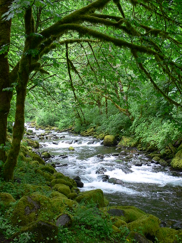
And who doesn't love flat paths alongside lovely little streams?? THEY ARE THE BEST! Although, is "stream" the right word? I always feel flummoxed about the correct river-ish word usage anytime I'm next to a river-ish thing. Is it a stream? Is it a creek? Is it JUST A RIVER?

Anyway.

When you haven't even been walking along this stream/creek/river very long, all of a sudden you are walking by this rather impressive mini waterfall shooting down over some sheer rock to your left. This is mainly impressive because you are literally right next to it, could reach out your hand and get wet, and it almost feels bizarre. This picture doesn't really do it justice, but believe me--it is RIGHT THERE!

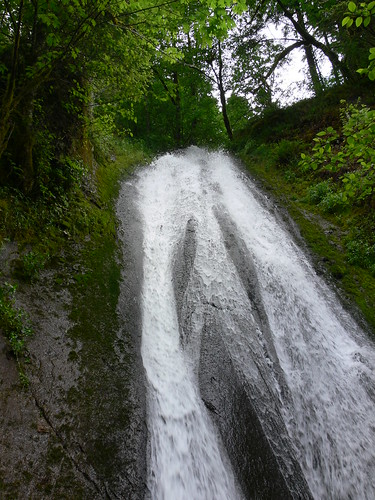
WHATTUP, WATERFALL RIGHT IN MY FACE!

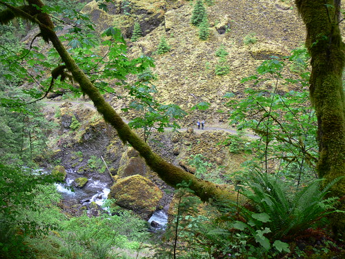
Wahclella is a balloon trail, meaning, it looks like a balloon--starts off as a straight trail with a loop trail at the end. Once the peaceful, stream-following path (seriously, so peaceful!) diverges off into the two trails leading to the left and right side of the balloon, it does start to get slightly steeper, and rockier, and thinner, but it still isn't too horrible. While it's a loop, and you can start it whatever way you want, I recommend heading left. This trail goes up, and up, and up away from that river-ish thing. Most of the time through the trees you can see the trail on the other side which you will be following back around in a little bit, and it seems pretty far below you at times.

Oh hey, gurl! We're going to be walking where you are soon!

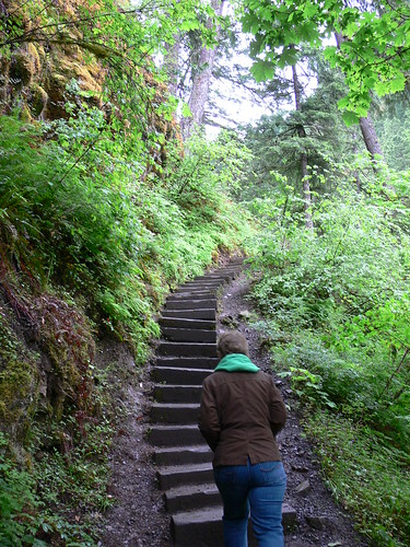
There's also one brief set of stairs on this path. I always really enjoy these things on a hike: 1) stairs, 2) bridges, and 3) if you're really lucky, a boardwalk over soggy or sensitive vegetation. Boardwalks are the best! But stairs and bridges are always good too. They're good landmarks and help break up the hike, and also makes you wonder each time, "Who the hell built these things?"


As with all good waterfall hikes, the best part about coming up to the Main Event is that you can HEAR it before you see it. And Wahclella Falls, as with most waterfalls in the Gorge in the spring, was really roaring this day. It's also surrounded by a semi-circle of huge rock walls and a great little waterfall pool, all of which elevate the sound of cascading water. (Such a great sound! Although kinda scary sometimes too!) The waterfall was so full this day that most of the rocks around the whole area--which you do have to somewhat trickily navigate to make your way to the other side of the stream--were pretty soaked. But I was able to precariously set up my camera and successfully self-time a picture of Kathy, myself, and my mom. Success!


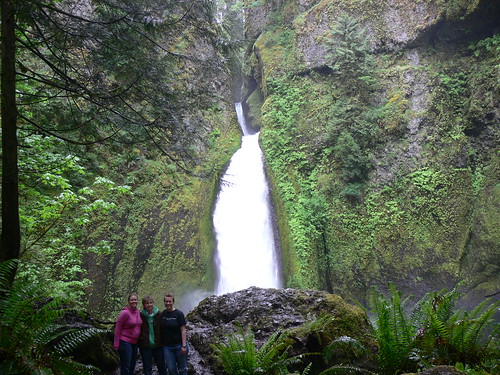
Such a great waterfall.

While somewhat rocky, this whole area around the waterfall and its pond also has a decent amount of open area, and it just screams, "I'm the perfect place for a pic-a-nic!" If you feel inclined to bring along a pic-a-nic basket. I haven't, in either of my two times there, but I've envisioned it.

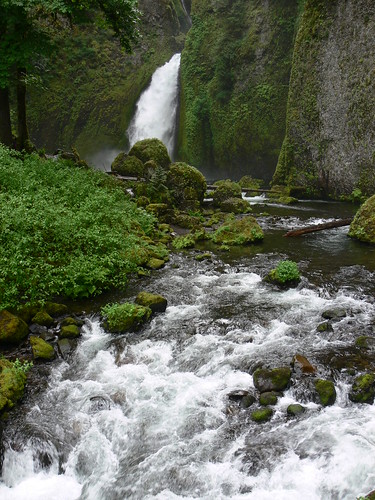
After scrambling over some rocks you walk over a small but sturdily built bridge to the other side of the pond, to start your walk around the other side of the balloon to get back to the string.


Once over the bridge, the stream is full of HUGE boulders, but is also relatively shallow and calm, and it's a perfect place for wading around, or letting your dogs wade around. If your dog isn't old and arthritic like ours, and can go on hikes. :(

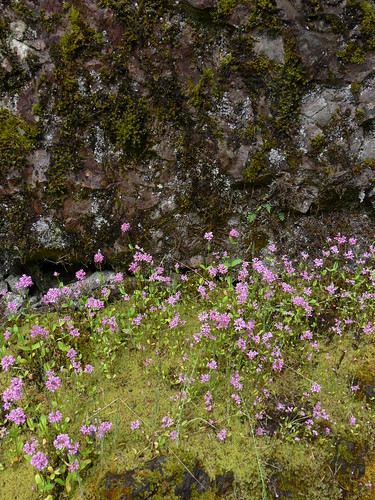
Continuing on the trail, this side is almost the opposite of the trail you were just on. Instead of being surrounded by trees, you're out in the open, a huge wall of rock to your left. This is my favorite part of the trail. The landscape is so interesting and wonderful, and since it's not as steep, you also really have the chance to look around and enjoy it.

What was so lovely about this walk too as opposed to the first time I walked it was that the trail this time was covered in little pinkish purple wildflowers EVERYWHERE. On this side of the trail, they peeked up on the riverbank and between every rock near the cliff wall, and there were LOTS of rocks, and lots of flowers.


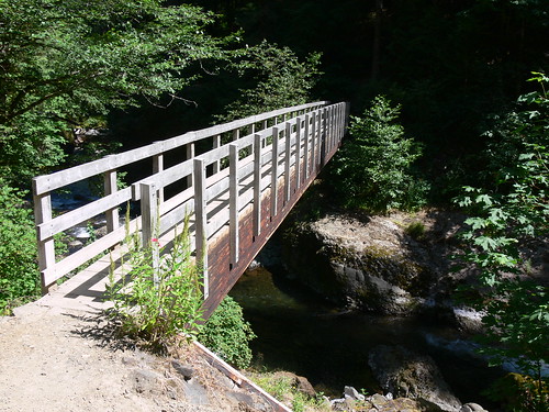
Too quickly, you're at another bridge, which connects you back to the main, more forested part of the trail which will lead you back to the parking lot. This bridge is a lot higher than the little one near the falls, and the view of the steam from it is pretty awesome.


There is one tricky part once you're over the bridge, where the trail seems to fork, and you swear you're back at the fork at the beginning of the balloon, and should go left--but going left actually just leads you to a kind of scary edge-of-a-cliff dead end. After going right and switchbacking just once or twice, you're back at the actual fork.

It's only a mile to the falls and a mile back, so all in all this hike shouldn't take more than an hour. But there's so much bang for your buck to it. I think it's the perfect waterfall to take visitors, or people who aren't in the mood for a mega-hike. The fact that apparently not as many people know about it is just an added bonus.

Lesson learned: There's no restroom at this trailhead, which was okay since it is a relatively short hike and we could survive until we drove to Hood River for lunch. However, peeing before you leave for a hike, or stopping somewhere before the trailhead where you CAN pee, just in case? Always a good idea.

Highlight: I did this hike the first time by myself, so it was really fun to take Kathy and my mom there. And, the aforementioned wildflowers.

Info: Heading east on I-84, take exit 40 for the Bonneville Dam. At the stop sign, take a right. There are actually two different trailheads here--head right for the parking lot for Wahclella Falls. The Northwest Forest Pass is required here; if you don't have it you can drop off a $5 fee in an envelope in a box at the entrance. Since there's not actually a forest ranger patrolling here or anything, these fees, as with most state parks and forests in Oregon, operate on trust. Since I have a guilty conscience, we paid the $5, but it's up to you if you want to take the chance. Hikers and dogs only.

Post-hike chow-down: The closest town to this hike is Cascade Locks, just slightly further east on I-84. There you'll find a number of solid American-food-esque burger joints, inns, and pubs, along with the East Wind Drive-In, a classic type of American institution. Kathy and I vet their burgers and their milkshakes. Limited seating inside, but it's the perfect type of food to grab and eat on the banks of the Columbia River, just feet away. You can also take the path we did this day, and drive on for 30 miles to Hood River, where the aforementioned Full Sail awaits, along with many, many other brewpubs and more diverse restaurants.

Friday, March 25, 2011

Cape Lookout.


Kathy and I took a day trip to the coast today, which somehow seemed like a momentous thing. One, we have been crazy busy with school and work and rarely have full days off together, and two, we are way poor, consequently making the idea of even just a DAY trip somewhere seem impossible as of late. But, we have both been fully aware that it's been over a YEAR since we took a true trip to the coast. Upon further inspection of my records, we did actually take the quickest of jaunts to Nehalem Beach in June 2010, but this was a mission to take our old, dog-aggressive/dog-anxious dog to see the ocean. While this was indeed wonderful and fun, since we were so worried about the other carefree, free-running dogs on the beach, and  since we also don't like leaving him in the car, we pretty much drove to the beach, walked around for about fifteen minutes, and promptly drove back to Portland. We felt victorious that we had given Toby the chance to romp around in the sea (well, 'romp around' might be some liberal phrasing--he is, as I mentioned, old--but, really, he was excited, in Toby terms!), but still, I don't believe this counts as a real trip. 

My records further show that the last time we took some actual trips to the coast was back in the summer of 2009, when we took a few different friends who visited us that summer. 2009! For those who are not aware, it's now 2011. This is a sad state of affairs when the glorious (and yes, as was recently and tragically reaffirmed to the world, often times scary) Pacific Ocean, with a violently majestic rocky coastline, is less than two hours away. Indeed, the first couple of years we lived here, it seemed like we took trips to the coast all the time--a stay at a yurt here, a day trip there, here a state park, there a state park, everywhere a yurt yurt--but apparently now the responsibilities of Real Life keep putting us in stay-put-in-Portland strangleholds. Which is highly unfortunate, because I could immediately tell today how much even just a day away can really do for your mental and emotional health.

Anyway, geez, enough of this boring back story. I love the ocean! Who doesn't! Glad we got that covered!

One of the things about the Oregon Coast which makes it different from other coasts--say, in Southern California, or almost anywhere along the East Coast, with maybe the exception of Maine--is that in addition to it being rocky, it is cold. And rainy. Most days of the year. It is not a place you go to lay out on a blanket and get a tan. It is, however, very pretty to look at! Indeed, Oregon made a smart move early on by preserving almost the entirety of its coast (through the likes of gallant oldies such as Oswald West) for the good and enjoyment of its people, making most of the coastline remarkably undeveloped. In any case, much of trips to the coast are normally spent, at least for us, in the car--driving around and looking at the pretty stuff! Which is nice--and warm, and dry, it should be noted--but today I really wanted to actually walk around a bit. So we headed for Cape Lookout.

Here's the theme of the Cape Lookout hike: mud.


Luckily, we came prepared with an extra pair of crappy old sneakers and extra socks, and the trail doesn't start out too bad. It begins with a slight downward-sloping track with a steep descent towards the water to your left. You can just barely see the water through a beautiful, orderly arrangement of tall, skinny Sitka spruce trees covered in dainty seafoam colored moss, as seen above. You can also hear the ocean quite well, so you know that it's there, and you know right away you are quite high up. And then suddenly, just about a half mile or less into the trail, the trees thin out and the descent to your left is now so steep you can't see anything to your immediate left but the wide, wide blue ocean--and, oh, yeah, there it is! Spread wide open before you! And you are really high up! And already kind of far out from the shoreline--because you are, you know, on a cape! And the water looks really blue! And you really do not want to trip and fall anywhere remotely close to the left side of the trail!


We stood and stared at this spot for quite awhile. Pictures do not convey how immense the ocean felt at that moment.

Cape Lookout is also known for being one of the best places to see whales, especially during spring and fall when they're moving along the coast, and so while we stood at this spot feeling on top of the world--there were seagulls flying over the water way below us that looked like tiny ants!--I may have also been whining, "I want to see a whale! I want to see a whale! I want to see a whaaaaale!" Alas, we didn't. Later, I learned that the best place to actually see them is at the tip of the Cape, where the hike ends. Spoiler alert: We didn't make it to the tip. (Deal with it.)


After this point the trail veers away from cliff side vistas and dives more into lovely coastal rainforest, with the slope also heading more and more downhill. And more and more muddy. It was fun, and we were happy. Slopping around in the mud--especially with the knowledge that we had dry shoes and socks back in the car--felt kind of awesome, in the way that doing things six year olds really enjoy usually generally feels awesome. While the mud might be worse during this time of the year, I suspect the trail is never completely dry, since my guidebook informed me that Cape Lookout gets over 100 inches of rain per year.

However, the shoes we brought really were just worn out sneakers with little traction, and as the trail became steeper and more like a true continuous mudpit, and as it started to rain a little harder than just the pleasant drizzle we had dealt with earlier, we decided to turn back. There was a pleasant couple of older ladies following us through most of the mud and at one point when we were really starting to slip and slide one of them said, "Ohhh, be careful! Once a mother, always a mother!" So there you go Mom--don't worry, there are kind Oregonians looking out for me.


There are some things that I am beginning to really appreciate about slightly-rainy/wet hikes. Mainly, the contrast between the dark oozy mud of the trail and the bright, shiny green of the ferns/grasses/plants elsewhere is enhanced and made even more beautiful. You also start to differentiate between your different shades of mud: here, there was the rust colored stuff, and then the real dark rich stuff. Squish, squish, squoosh. If I knew more about geology, I would tell you what those different colors mean, but I don't. I just think noticing different shades of mud on the same trail is neat. I'm smart!

This is the second hike in as many attempts that Kathy and I haven't completed the full loop of, but I feel okay with it. We are still just starting to flex our hiking muscles. In all we hiked about two miles this trip, which isn't too shabby (okay, by outdoorsy Oregonian standards, it's pretty shabby). Also, in both cases, we had a dinner involving good beer ahead of us always in the back of our minds. So. You understand.

Lesson learned: I really should invest in real hiking books. Also, when tramping through mud, rolling up my jeans just once or twice is NOT enough.


Highlight: That awe-inspiring viewpoint, obviously. Also, spotting a bunch of white trilliums peeking up here and there almost every other step. And, making Kathy stand next to this thing.


Info: Located within Cape Lookout State Park off of Rt. 131 between Tillamook and Pacific City, also known as the Three Capes Scenic Route. There's also a more direct road connecting the park to Rt. 101, Sandlake Road. The entrance to the trailhead is well marked, but is different from the entrance to the park camping area. There are also trails leading down to the beach, and to the campsite. Dogs allowed but must be on leash. One portapotty at the parking lot. No permits required.

Post-hike chow-down: I highly recommend heading just a few miles south on 131 to Pacific City for a nice relaxing meal at the Pelican Pub & Brewery. It's right on the beach at Cape Kiwanda, and prices are in a good middle rage--not totally cheap, but not totally expensive, and overall way worth your buck. Hands down, this is one of my favorite places in Oregon. Open seven days a week; open for breakfast, lunch, and dinner.