Tuesday, September 17, 2013

Tamanawas Falls.

Here's something funny: in both my Oregon hiking guidebook and on every website I perused, Tamanawas Falls on the northeast side of Mt. Hood was listed as "easy." I...would disagree with this. But perhaps when you are comparing trails to others in the vicinity that regularly crest mountain ridges at thousands of feet in the air and stuff, "easy" becomes a relative term.

They are also real into Robin Hood around these parts, which can never be a bad thing.

I mean, there were many easy and pleasant parts of it. For instance, a few feet away from where you park your car off of US 35 in Mt. Hood National Forest, you get to traverse a high bridge over the East Fork of the Hood River, swiftly running glacial waters colored a very pale and cold-looking silt-tumbled grey. I love a good bridge! I have probably mentioned this fact before in this severely neglected blog, but it's worth repeating. Who doesn't love a good bridge! And there's even another great one on this trail to come!

New addition to hike photos: dog!

In fact, I should state right off that even beyond the bridges, this is an utterly fantastic and enjoyable trail, and I loved it. There were just some less "easy" parts of it. After you cross the bridge, you follow the East Fork as it, in turn, follows the highway. Even after you eventually take a turn deeper into the woods, you can still hear the traffic along the highway for a while, which doesn't particularly bother me, but I know for some real escaping-into-nature-is-my-jam folk, it might. But don't worry, it'll disappear soon.


Being as late August and September are some of the driest times of the year to visit Mt. Hood--we went to make the most of an Indian summer heat wave--the beginning of the trail here was very sandy, and there were portions both here and later on that included extremely steep drop offs. As in, trip or make a wrong step a foot or two in a bad direction, and bye bye it is for you. I've obviously walked on trails like this before, but there were parts that seemed particularly harrowing, which I probably only felt more acutely because of the very big and strong dog now traveling with us.

You soon reach the second lovely bridge, which is smaller but feels sturdier than the first one.


Past this bridge is where things really begin to get lovely. From here on out the trail closely hugs Cold Spring Creek, which is pretty much magnificent. The further along you walk, the more it goes from calm and pretty to white water-y and a little intimidating. The trail continues to climb slowly in elevation, and while a lot of times you're climbing over rocks, there are also these pockets where all of a sudden you're enclosed in soft green and it feels like magic. I always feel like I'm walking into the Secret Garden or some type of Disney movie in these magic spots on hikes, which are also always hard to accurately capture in pictures.


There are multiple spaces where the riverbank flattens out, practically begging you to rest and bring a picnic there, and there are some mini waterfalls along the way that are just real great.


We passed a few older couples on their way back from the falls, as this is a there-and-back hike, who were overjoyed with the final payoff and really built the whole thing up for us, as excited tourists who don't spend enough time in the woods really like to share their happiness here in the Northwest. The second couple said, "The falls are great...if you make it." IF YOU MAKE IT. We were already getting a little tired at this point, since we are weaklings, and now we trudged forward with the knowledge that we might not even make it! Awesome!

We also passed one woman walking by herself with some serious walking sticks who didn't say a thing to us. We assumed she probably belonged to the only car in the parking lot that actually displayed the Forest Pass like you were supposed to, as opposed to the rest of us slackers.

Things only really felt bleak when all of a sudden the trail became a path through a mountain of boulders.


I had read that you had to do a scramble over rocks if you really wanted to get to the falls, and considering we couldn't even see the falls yet, I thought this was the start of the scramble, and these were some seriously big rocks, and we are not scrambling people. Alas! This was just part of the trail, and not a bad one at that, apart from the REALLY SCARY BEES AND BUGS that were delighting in the open sunny air. BEWARE THE REALLY SCARY BEES AND BUGS.

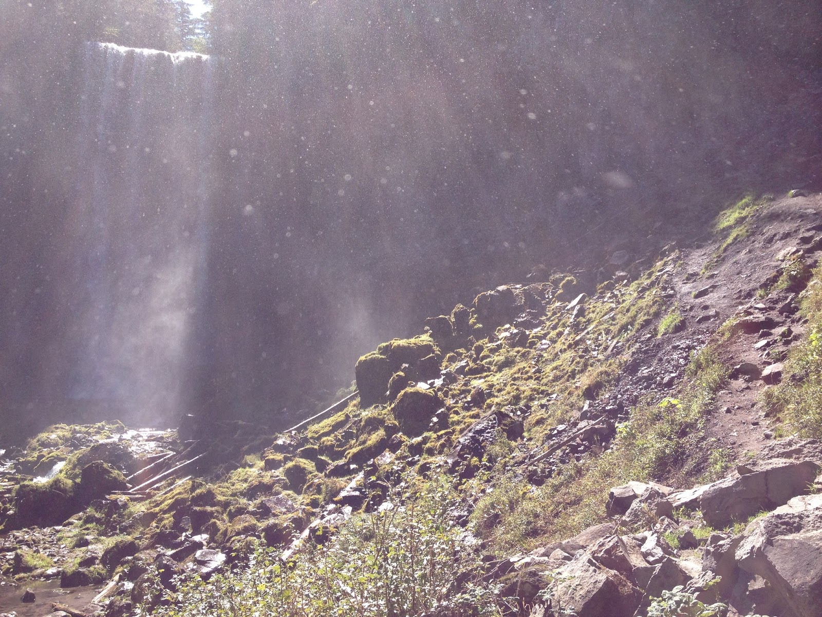
After a bit more walking, you finally see the falls, which drop an impressive 100 feet. And they are, indeed, great. They appear somewhat suddenly, and the height really does take your breath away for a second.

Tamanawnanwasnas Falls!

The trail continues to narrow the closer you get until it just sort of disintegrates, and this is where the actual scrambling part happens, where you can apparently walk behind the falls and it is splendid. Which, you know, we didn't do, because we are not scramblers.

Instead we stood as close as we felt comfortable and let the enormous shifting spray from the falls tinkle over our sweaty faces. On top of this, out of nowhere, there were a million butterflies dancing around our heads, no joke, because the Northwest is just a stupidly beautiful place. Although to be honest, I couldn't always tell whether those tiny wings flapping past my ear were butterflies or the aforementioned scary huge bees, so I was a little more anxious about the whole situation. But for normal people, it would've been fantastic.

But this really did feel seriously awesome.

Then we turned around and went back.

An example of "not necessarily easy."

This was the only serious outside-of-Portland hike we've done this year, and only the third I've done in the Mt. Hood area in all the years we've now been here (the others being the popular Mirror Lake and the crazy amazing Lost Lake). I feel like I always say the same things when we actually get out on a hike together: why don't we do this more; we need to do this more. The fact is that we did do this more when we first lived here, when I wanted to explore every acre of this new land. I still want to explore every acre, but completely unsurprisingly, real life settles in more and more, and there seems to be less and less time and energy for things like exploring. I originally was planning on making some renewed hiking promise to myself after this wonderful day last week that we drove to Mt. Hood, but a few days later, I think what I want to say is just how glad I am that we get to have any of these wonderful days at all.

Lesson learned: Buy a forest pass, dummy.

Highlight: Seeing our dog, who has arthritis, jumping up rocks like a champ. Also, seeing fantastic views of Mt. Adams on the way back to Portland through Hood River, which we only realized afterwards was actually the faster route.

Info: Coming from Portland on 26, pass Government Camp to turn onto 35 North. Travel until you see signs for Sherman Campground. The easily visible trail marker will be on your left right after. From Hood River, travel 25 miles south on 35. Northwest Forest Pass required. While other Forest Pass hikes I've done have included honor-system pay stations at the trailhead, this one did not, so if you are a truly responsible citizen, you should stop at a ranger or information station to get one. (We did not get a ticket.) There was a porta-potty in the parking lot, but a safer bet would be the public rest stop at Government Camp. Hikers and dogs only

Post-hike chow-down: Government Camp is the closest town, where we have stopped at the Mt. Hood Brewery before, although there are surely other options in this little alpine hamlet as well. We did not really have a post-hike chow-down this time, but on the way out of Portland, we did have a pre-hike breakfast of boba tea and a breakfast baguette at Best Baguette, which was the perfect fuel, and where we also learned that one breakfast baguette is most definitely enough for two people.

Friday, July 8, 2011

Wahclella Falls.

Wahclella Falls is the only hike I've now completed twice. And I might take my dad there when he visits next week and complete it thrice! Although I haven't decided yet. Normally with hikes, as with books and other things, no matter how much I liked one, there are so many amazing and tantalizing OPTIONS out there that it's hard for me to repeat. But Wahclella Falls is so simple and easy and lovely that it's hard to resist.

It's in my beloved Columbia River Gorge, although a little further out from Portland than the cluster of ridiculously beautiful and ridiculously popular hikes in the Multnomah Falls area. To get there, you push on on I-84, past Eagle Creek, until you reach the exit for the Bonneville Dam, roughly 30 miles from Hood River. This is still only an hour or so from Portland. There is not much off of this exit, except for the Bonneville Dam--and if you have an interest in fish ladders and big scary dams, go to it!--and the parking lot for this hike.

It starts off on a wide flat path right along this lovely little stream.


And who doesn't love flat paths alongside lovely little streams?? THEY ARE THE BEST! Although, is "stream" the right word? I always feel flummoxed about the correct river-ish word usage anytime I'm next to a river-ish thing. Is it a stream? Is it a creek? Is it JUST A RIVER?

Anyway.

When you haven't even been walking along this stream/creek/river very long, all of a sudden you are walking by this rather impressive mini waterfall shooting down over some sheer rock to your left. This is mainly impressive because you are literally right next to it, could reach out your hand and get wet, and it almost feels bizarre. This picture doesn't really do it justice, but believe me--it is RIGHT THERE!

WHATTUP, WATERFALL RIGHT IN MY FACE!

Wahclella is a balloon trail, meaning, it looks like a balloon--starts off as a straight trail with a loop trail at the end. Once the peaceful, stream-following path (seriously, so peaceful!) diverges off into the two trails leading to the left and right side of the balloon, it does start to get slightly steeper, and rockier, and thinner, but it still isn't too horrible. While it's a loop, and you can start it whatever way you want, I recommend heading left. This trail goes up, and up, and up away from that river-ish thing. Most of the time through the trees you can see the trail on the other side which you will be following back around in a little bit, and it seems pretty far below you at times.

Oh hey, gurl! We're going to be walking where you are soon!

There's also one brief set of stairs on this path. I always really enjoy these things on a hike: 1) stairs, 2) bridges, and 3) if you're really lucky, a boardwalk over soggy or sensitive vegetation. Boardwalks are the best! But stairs and bridges are always good too. They're good landmarks and help break up the hike, and also makes you wonder each time, "Who the hell built these things?"


As with all good waterfall hikes, the best part about coming up to the Main Event is that you can HEAR it before you see it. And Wahclella Falls, as with most waterfalls in the Gorge in the spring, was really roaring this day. It's also surrounded by a semi-circle of huge rock walls and a great little waterfall pool, all of which elevate the sound of cascading water. (Such a great sound! Although kinda scary sometimes too!) The waterfall was so full this day that most of the rocks around the whole area--which you do have to somewhat trickily navigate to make your way to the other side of the stream--were pretty soaked. But I was able to precariously set up my camera and successfully self-time a picture of Kathy, myself, and my mom. Success!


Such a great waterfall.

While somewhat rocky, this whole area around the waterfall and its pond also has a decent amount of open area, and it just screams, "I'm the perfect place for a pic-a-nic!" If you feel inclined to bring along a pic-a-nic basket. I haven't, in either of my two times there, but I've envisioned it.

After scrambling over some rocks you walk over a small but sturdily built bridge to the other side of the pond, to start your walk around the other side of the balloon to get back to the string.


Once over the bridge, the stream is full of HUGE boulders, but is also relatively shallow and calm, and it's a perfect place for wading around, or letting your dogs wade around. If your dog isn't old and arthritic like ours, and can go on hikes. :(

Continuing on the trail, this side is almost the opposite of the trail you were just on. Instead of being surrounded by trees, you're out in the open, a huge wall of rock to your left. This is my favorite part of the trail. The landscape is so interesting and wonderful, and since it's not as steep, you also really have the chance to look around and enjoy it.

What was so lovely about this walk too as opposed to the first time I walked it was that the trail this time was covered in little pinkish purple wildflowers EVERYWHERE. On this side of the trail, they peeked up on the riverbank and between every rock near the cliff wall, and there were LOTS of rocks, and lots of flowers.


Too quickly, you're at another bridge, which connects you back to the main, more forested part of the trail which will lead you back to the parking lot. This bridge is a lot higher than the little one near the falls, and the view of the steam from it is pretty awesome.


There is one tricky part once you're over the bridge, where the trail seems to fork, and you swear you're back at the fork at the beginning of the balloon, and should go left--but going left actually just leads you to a kind of scary edge-of-a-cliff dead end. After going right and switchbacking just once or twice, you're back at the actual fork.

It's only a mile to the falls and a mile back, so all in all this hike shouldn't take more than an hour. But there's so much bang for your buck to it. I think it's the perfect waterfall to take visitors, or people who aren't in the mood for a mega-hike. The fact that apparently not as many people know about it is just an added bonus.

Lesson learned: There's no restroom at this trailhead, which was okay since it is a relatively short hike and we could survive until we drove to Hood River for lunch. However, peeing before you leave for a hike, or stopping somewhere before the trailhead where you CAN pee, just in case? Always a good idea.

Highlight: I did this hike the first time by myself, so it was really fun to take Kathy and my mom there. And, the aforementioned wildflowers.

Info: Heading east on I-84, take exit 40 for the Bonneville Dam. At the stop sign, take a right. There are actually two different trailheads here--head right for the parking lot for Wahclella Falls. The Northwest Forest Pass is required here; if you don't have it you can drop off a $5 fee in an envelope in a box at the entrance. Since there's not actually a forest ranger patrolling here or anything, these fees, as with most state parks and forests in Oregon, operate on trust. Since I have a guilty conscience, we paid the $5, but it's up to you if you want to take the chance. Hikers and dogs only.

Post-hike chow-down: The closest town to this hike is Cascade Locks, just slightly further east on I-84. There you'll find a number of solid American-food-esque burger joints, inns, and pubs, along with the East Wind Drive-In, a classic type of American institution. Kathy and I vet their burgers and their milkshakes. Limited seating inside, but it's the perfect type of food to grab and eat on the banks of the Columbia River, just feet away. You can also take the path we did this day, and drive on for 30 miles to Hood River, where the aforementioned Full Sail awaits, along with many, many other brewpubs and more diverse restaurants.

Friday, March 25, 2011

Cape Lookout.


Kathy and I took a day trip to the coast today, which somehow seemed like a momentous thing. One, we have been crazy busy with school and work and rarely have full days off together, and two, we are way poor, consequently making the idea of even just a DAY trip somewhere seem impossible as of late. But, we have both been fully aware that it's been over a YEAR since we took a true trip to the coast. Upon further inspection of my records, we did actually take the quickest of jaunts to Nehalem Beach in June 2010, but this was a mission to take our old, dog-aggressive/dog-anxious dog to see the ocean. While this was indeed wonderful and fun, since we were so worried about the other carefree, free-running dogs on the beach, and  since we also don't like leaving him in the car, we pretty much drove to the beach, walked around for about fifteen minutes, and promptly drove back to Portland. We felt victorious that we had given Toby the chance to romp around in the sea (well, 'romp around' might be some liberal phrasing--he is, as I mentioned, old--but, really, he was excited, in Toby terms!), but still, I don't believe this counts as a real trip. 

My records further show that the last time we took some actual trips to the coast was back in the summer of 2009, when we took a few different friends who visited us that summer. 2009! For those who are not aware, it's now 2011. This is a sad state of affairs when the glorious (and yes, as was recently and tragically reaffirmed to the world, often times scary) Pacific Ocean, with a violently majestic rocky coastline, is less than two hours away. Indeed, the first couple of years we lived here, it seemed like we took trips to the coast all the time--a stay at a yurt here, a day trip there, here a state park, there a state park, everywhere a yurt yurt--but apparently now the responsibilities of Real Life keep putting us in stay-put-in-Portland strangleholds. Which is highly unfortunate, because I could immediately tell today how much even just a day away can really do for your mental and emotional health.

Anyway, geez, enough of this boring back story. I love the ocean! Who doesn't! Glad we got that covered!

One of the things about the Oregon Coast which makes it different from other coasts--say, in Southern California, or almost anywhere along the East Coast, with maybe the exception of Maine--is that in addition to it being rocky, it is cold. And rainy. Most days of the year. It is not a place you go to lay out on a blanket and get a tan. It is, however, very pretty to look at! Indeed, Oregon made a smart move early on by preserving almost the entirety of its coast (through the likes of gallant oldies such as Oswald West) for the good and enjoyment of its people, making most of the coastline remarkably undeveloped. In any case, much of trips to the coast are normally spent, at least for us, in the car--driving around and looking at the pretty stuff! Which is nice--and warm, and dry, it should be noted--but today I really wanted to actually walk around a bit. So we headed for Cape Lookout.

Here's the theme of the Cape Lookout hike: mud.


Luckily, we came prepared with an extra pair of crappy old sneakers and extra socks, and the trail doesn't start out too bad. It begins with a slight downward-sloping track with a steep descent towards the water to your left. You can just barely see the water through a beautiful, orderly arrangement of tall, skinny Sitka spruce trees covered in dainty seafoam colored moss, as seen above. You can also hear the ocean quite well, so you know that it's there, and you know right away you are quite high up. And then suddenly, just about a half mile or less into the trail, the trees thin out and the descent to your left is now so steep you can't see anything to your immediate left but the wide, wide blue ocean--and, oh, yeah, there it is! Spread wide open before you! And you are really high up! And already kind of far out from the shoreline--because you are, you know, on a cape! And the water looks really blue! And you really do not want to trip and fall anywhere remotely close to the left side of the trail!


We stood and stared at this spot for quite awhile. Pictures do not convey how immense the ocean felt at that moment.

Cape Lookout is also known for being one of the best places to see whales, especially during spring and fall when they're moving along the coast, and so while we stood at this spot feeling on top of the world--there were seagulls flying over the water way below us that looked like tiny ants!--I may have also been whining, "I want to see a whale! I want to see a whale! I want to see a whaaaaale!" Alas, we didn't. Later, I learned that the best place to actually see them is at the tip of the Cape, where the hike ends. Spoiler alert: We didn't make it to the tip. (Deal with it.)


After this point the trail veers away from cliff side vistas and dives more into lovely coastal rainforest, with the slope also heading more and more downhill. And more and more muddy. It was fun, and we were happy. Slopping around in the mud--especially with the knowledge that we had dry shoes and socks back in the car--felt kind of awesome, in the way that doing things six year olds really enjoy usually generally feels awesome. While the mud might be worse during this time of the year, I suspect the trail is never completely dry, since my guidebook informed me that Cape Lookout gets over 100 inches of rain per year.

However, the shoes we brought really were just worn out sneakers with little traction, and as the trail became steeper and more like a true continuous mudpit, and as it started to rain a little harder than just the pleasant drizzle we had dealt with earlier, we decided to turn back. There was a pleasant couple of older ladies following us through most of the mud and at one point when we were really starting to slip and slide one of them said, "Ohhh, be careful! Once a mother, always a mother!" So there you go Mom--don't worry, there are kind Oregonians looking out for me.


There are some things that I am beginning to really appreciate about slightly-rainy/wet hikes. Mainly, the contrast between the dark oozy mud of the trail and the bright, shiny green of the ferns/grasses/plants elsewhere is enhanced and made even more beautiful. You also start to differentiate between your different shades of mud: here, there was the rust colored stuff, and then the real dark rich stuff. Squish, squish, squoosh. If I knew more about geology, I would tell you what those different colors mean, but I don't. I just think noticing different shades of mud on the same trail is neat. I'm smart!

This is the second hike in as many attempts that Kathy and I haven't completed the full loop of, but I feel okay with it. We are still just starting to flex our hiking muscles. In all we hiked about two miles this trip, which isn't too shabby (okay, by outdoorsy Oregonian standards, it's pretty shabby). Also, in both cases, we had a dinner involving good beer ahead of us always in the back of our minds. So. You understand.

Lesson learned: I really should invest in real hiking books. Also, when tramping through mud, rolling up my jeans just once or twice is NOT enough.


Highlight: That awe-inspiring viewpoint, obviously. Also, spotting a bunch of white trilliums peeking up here and there almost every other step. And, making Kathy stand next to this thing.


Info: Located within Cape Lookout State Park off of Rt. 131 between Tillamook and Pacific City, also known as the Three Capes Scenic Route. There's also a more direct road connecting the park to Rt. 101, Sandlake Road. The entrance to the trailhead is well marked, but is different from the entrance to the park camping area. There are also trails leading down to the beach, and to the campsite. Dogs allowed but must be on leash. One portapotty at the parking lot. No permits required.

Post-hike chow-down: I highly recommend heading just a few miles south on 131 to Pacific City for a nice relaxing meal at the Pelican Pub & Brewery. It's right on the beach at Cape Kiwanda, and prices are in a good middle rage--not totally cheap, but not totally expensive, and overall way worth your buck. Hands down, this is one of my favorite places in Oregon. Open seven days a week; open for breakfast, lunch, and dinner.

Thursday, November 11, 2010

Deschutes State Park River Trail.


Here's a not-so-secret: I have a love affair with Oregon rivers. I met my #1 love, the Rogue, this summer in Southern Oregon, but after that, my #2 so far is the Deschutes. (This may or may not be influenced by the fact that I am also really in love with Deschutes beer.)

Kathy and I headed out to Deschutes State Park yesterday, on the Columbia River Gorge way out past The Dalles, to celebrate a few things: 1) our six year anniversary this week, and 2) the miracle of both having all day on Veteran's Day off in the midst of our crazy schedules. I truly am grateful and in awe of veterans, and thank them even more for allowing us one of the most perfect days ever. While the Deschutes is best known for traveling through the heart of Bend, a magical city in Central Oregon (where that wonderful beer also originates!), this state park is located much farther north, where the Deschutes empties into the mighty Columbia.

I love the Columbia River Gorge for so many reasons, and for the first year or two that I lived here jaw-dropping waterfalls occupied most of those reasons, but after exploring it more I'm in even more awe of its diversity. The hour-long drive from Portland to Hood River is one I could never tire of, even if it is on a big highway like I-84. Yeah, it's a highway, but it's one that's deliciously sandwiched between wide expanses of the Columbia on one side and towering green cliffs and hills on the other. On this Portland to Hood River expanse it is all about luscious green-ness, waterfalls and slabs of rock covered in moss and towering fir trees every which way you look, with hills constantly receding into varying shades of blues in the distance, dream-like.This section is home to the famous Multnomah Falls, among many, many others; a wonderfully twisty-turvy section of the historic Columbia River Highway, Route 30; and the stunning overlook spot, the Vista House at Crown Point.

And then you pass Hood River. And almost as soon as you drive out of city limits, it's like you're in a completely different landscape altogether.

The river is still there, wide and steady to your left, but there are less trees and less moss, less green altogether, more brown rolling hills. It's an arid, desert-y kind of feel, but not quite the desert, just...different. You've left the hippie-loving western side of the state, and are suddenly closer to the Wild Wild West. It's a difference you not just see, but you feel. As majestic as all the stuff before Hood River was, this landscape actually seems bigger, in a way, and you accordingly feel smaller. It's totally different but still totally the Gorge, and still totally amazingly beautiful. And yes, that was a lot of totally's. This is the way the crazy Oregon landscape makes me feel! You can practically see the dreamy stars in my eyes! Snap out of it, Jill!

The trail we embarked on (from the furthest parking lot of the park) is a narrow single track which hugs the river, which is wide and pretty peaceful at this conclusive juncture of its life. The trail is pretty flat and on-level with the river at first, with a spattering of sparse, spindly trees surrounding the river, the trail and you, and then slowly, increasingly makes its way to slightly higher ground, with the river slightly further below you and the trees--or any real vegetation at all--becoming even sparser. And everywhere, it is quiet, quiet. Every now and then you look back where you came from, and all you see in every direction are big, dusty, quiet hills.

Peaceful quiet is definitely the thing I remember most from this hike--we didn't see another soul the whole time we were out. Even though I-84 isn't too far from the start of the trail, even whirring traffic noises from that fade out pretty quickly, and it's just you, the birds, and the river. We eventually turned around to head back a little earlier than I anticipated (the trail keeps going for quite a ways along the river), because it was starting to get dark and also starting to rain a little, and unlike other well forested hikes I'm used to, there wasn't any real cover from the wetness out here. But it still felt good to stretch our legs a little, and to breathe some drier Central Oregon air. Central/Eastern Oregon, I want so much more of you! Oregon Rivers, you and I are not over yet!

Lesson learned: If I want to actually complete these hikes, we really have to start out earlier. And also come more prepared with snacks. Also, the farther out from Portland/cities you go, the less populated the trails will be. While this is nice in a way, it's also a reaffirmation for me that I shouldn't do these trails alone.

Highlight: The random, bright sprinklings of fall color (red bushes! yellow leaved trees! purple flowers!) mixed in with all the shades of brown.

Info: Heading east on I-84, Deschutes River State Park is located off of Exit 97, on Rt. 206. There are a few different trails in the park, including a wider one for bikers, but to get to the River Trail we took, you have to first walk through a small field at the end of the last parking area. Horses (yeah, horses!) allowed with reservation. Restrooms and picnic tables available near parking lot.

Post-hike chow-down: If you're heading back Portland-way after the hike, you should probably stop in Hood River for a meal at Full Sail Brewery, because their beer and food are delicious, and their brewpub is small and fun and, during the day, you can watch windsurfers on the Columbia while you eat. On this trip we were going to try and branch out and eat at the smaller Double Mountain Brewery, which is actually right around the corner, but it was crowded and no one helped us after we stood around confusedly for ten minutes, so we walked out. Which ended up being okay, because we remembered how much we completely love Full Sail, so it's never a bad option. But, still, Double Mountain also came recommended. Both are located on Columbia Street, Hood River (Double Mountain technically on the corner of Fourth); open daily for lunch and dinner. Full Sail also offers free brewery tours daily.

Saturday, October 16, 2010

Minto-Brown Island Park.


Life has been hectic the last month or so: Kathy and I are both pretty insanely busy with school; I am constantly stressed about money; and we've traveled hundreds of miles to attend two different weddings over two different weekends. Said weddings and weekends full of travel were awesome, but still, the prospect of a weekend just spent in good ol' Oregon, with pretty much Saturday and Sunday open free to do with as I pleased, had me silly-giddy-excited Friday night. We went to the movies! I avoided homework and tried not to stress too much about money! Tomorrow we're going pumpkin-patch-ing! We watched some TV! And for the first time in quite awhile, I went on a hike!

Okay, considering I chose Minto-Brown Island Park in Salem, which is 835 acres of pretty flat ground in the floodplain of the Willamette River, and almost every path I walked on was paved, it probably counts more as a casual stroll than a hike, per se. But considering I strolled five miles, it was still a pretty lengthy stroll, and I was still pretty darned tired after about an hour. Okay, secret time: even though I profess to love hiking, I still don't know if I'm actually a good hiker. I know I'm pretty out of shape, both in general and in terms of hiking, but what happened today is kind of what happens every time I venture out into the wilderness:

For the first twenty minutes or so, I am in a state of euphoria. Here I am, out of the house, away from the worries of the world! Breathe that fresh air! Look at that sky, look at these trees, listen to those birds chirping and those squirrels and insects bustling through the bushes! The world is quiet, and still, yet full of life. I love nature, and I'm so happy to be out exploring it!

And then, usually after about an hour or so:

Hm. I am getting kind of tired. My feet hurt a little. Everything is still so beautiful, I still love all these trees, but the capacity of my mind to actually process and appreciate it all seems to be waning a little bit. And you know what, I really have a lot of homework to do back home. And, hm, there are a lot of dirty dishes still hanging out in the sink, and a bunch of laundry, and a bunch of emails I should've sent a week ago. And I still have to finish that book, and that stack of newspapers! And you know I really don't spend enough time with the animals. I wish I was with them now, cuddled up in bed. I mean I really like it here, really, but it'd also be really awesome to be back there. I wonder what Kathy's doing? I miss her.

There are two possible reasons behind this: 1) I am still not a very good hiker, or, 2) Even though I love alone time and always have, in the end, nothing is really as much fun anymore without Kathy there.

Regardless--Minto-Brown Island Park was lovely. I don't usually have much reason to visit Salem, but it felt fun to go on a mini-road-trip by myself, to feel away from it all for just a couple of hours. It was also nice to have a slightly different pace than previous hikes I've been on, the majority of which have been concentrated in the Gorge. And really, I will never get sick of the Gorge. But at the same time, it's nice to take a step back from the drama of the waterfalls, cliffs, lush greenery moss-fest that occupies every hike there, and visit a wildlife refuge such as Minto-Brown, full of fields, chirping birds, marshes, and quiet paths through cottonwoods.

In fact, there is something about walking through flat, open fields that is incredibly and deeply calming at the same time that it is beautiful. Also, truth: I am in love with the types of trees that were all around this park, trees with pale, peely bark, although I couldn't tell you the exact kinds that were there (other than cottonwoods, because my guide book told me that): birches, ashes, cottonwoods, trees that grow in clumps with one sprawling root system and that grow well in the aftermath of fire. I grew up in, and know, dense woods of oak and pine, but there is something different, and very lovely, about these kinds of trees: an airiness, a lightness. It was especially lovely to be here in fall, and I alternated between delightedly shuffling through the crisp crinkly leaves on all the paths like a happy kid and feeling guilty at my really-not-stealthy walking through the wilderness.

Lesson learned: Although it was a nice walk, being that almost all of the paths were wide, well paved, and multi-use, this probably really would be best enjoyed as a bike ride.

Highlight: Seeing a majestic, still blue heron ten feet away from me. So close and still that I actually thought it wasn't real at first, until it flew away from me when I went to reach for my camera.

Info: Located in South Salem on the Willamette River, off of River Road. Park website can be found here; no fees. Restrooms (portapotties) & picnic areas available; dogs and bikes welcomed.